
About This Course
ArcGIS Pro provides tools to efficiently organize, create, and manage data. In this course, learn about some common types of data used for GIS mapping and analysis, and practice adding data to a file geodatabase to support a planned project.
Learning Objectives
Be able to perform the following tasks:
- Create a geodatabase in ArcGIS Pro.
- Create feature classes in ArcGIS Pro by exporting and importing data.
- Create a new, empty feature class in ArcGIS Pro
Data Formats
Vector
Shapefiles and CAD files are two common data formats that define feature and attribute information using a series of files that can be stored within a folder. when importing these into a geodatabase, the format is converted from a shapefile or CAD file into a geodatabase feature class. The feature class contains the same feature and attribute information, but this information is defined within a geodatabase.
Raster
Raster data is often stored in image file formats such as TIFF, JPEG, and NITF. These formats are commonly referred to as raster datasets. These datasets are managed in the geodatabase as a mosaic dataset that references the raster datasets. A mosaic dataset provides more features and functionality to help you manage raster datasets.
Tabular
Tabular data is often stored in Microsoft Excel, text, and CSV file formats. These files usually contain attribute information and locational information, such as x,y coordinates and addresses. Importing these tables into a geodatabase converts the format into a geodatabase table.
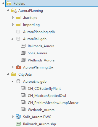
Importing data into geodatabase
A variety of data sources were integrating into one geodatabase for analysis. Formats included Shape files and DWG CAD drawings.
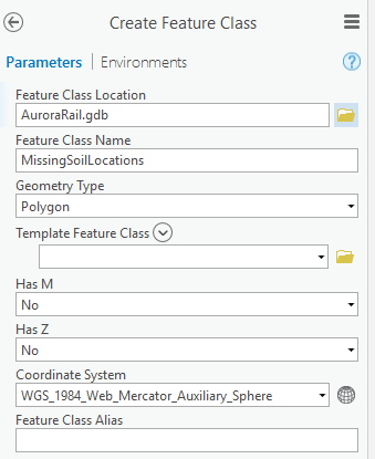
Feature Classes
When creating a feature class, the properties must be defined. Feature class properties determine what sort of information can be stored in the feature class and how it will display on a map.
- Geometry type: including points, polylines, or polygons
- Template Feature Class: defines the features attributes based on the attribute table of an existing class feature
- Has M or Z: the Has M property determines whether features will contain linear measurement information (M Values). The Has Z property is for elevation information (Z Values)
- Coordinate System: defines how the features will be located on the earth and how they will project onto a map.
Certificate

Recent Comments